Geocoding

Geocode Lookup

Geocode Lookup Solutions for Accurate Address Location Data

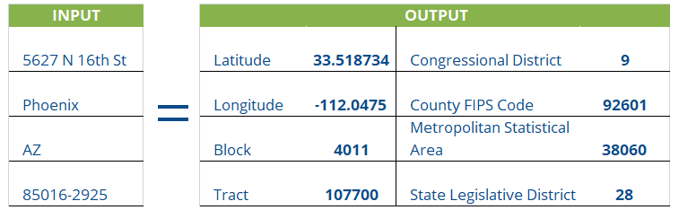
Geocode lookup technology helps businesses convert addresses into precise geographic coordinates. In addition, it assigns accurate location data to records within an address database. By adding latitude and longitude coordinates along with other location-based details, geocode lookup solutions improve address intelligence, mapping accuracy, and geographic analysis.

With accurate geocode lookup data, businesses can also perform a wide range of location-based tasks. For example, they can calculate distances between locations, identify addresses within a defined radius, and organize mailing and sales territories. Furthermore, they can analyze customer distribution geographically, improve targeted marketing campaigns, and locate the nearest distribution centers or service outlets for customers.

Geocode Lookup | Geocoding API for Address Verification | SmartSoftDQ

How Does Geocoding Work?

SmartSoftDQ’s AccuMail GeoCode is easy to use. In addition, when used with the AccuMail .NET API or the AccuMail desktop address correction application, it allows businesses to seamlessly integrate geolocation data during the address validation and correction process. As a result, location data can then be used in other applications, either directly through the .NET API or by exporting it from the AccuMail frameworks desktop database.

AccuMail GeoCode is also available as an add-on for the AccuMail framework desktop application or as an API that can be integrated into custom applications for real-time latitude and longitude processing.

Furthermore, beyond providing latitude and longitude coordinates to up to six decimal places, AccuMail GeoCode delivers a wide range of additional data for each address:


Rich Data

Appends Latitude/Longitude coordinates to 6 decimal places, along with additional data points.

Integrative Data

Seamlessly export data to other applications that utilize geographic data, such as graphical mapping programs.

Application Scalability

.NET Toolkit version available for third-party application integration.

Geocoding Uses

Customer Data Enrichment

In addition, businesses can combine Census Tract and Block Number data, which is provided down to the ZIP+4® level, with Census-based demographic data from third-party sources. As a result, they can develop more detailed and accurate customer profiles. Furthermore, this enriched data helps improve audience targeting, strengthen market analysis, and support more informed business decisions.

Sales Tool

In addition, geocode data can help organizations create fair and balanced sales territories. As a result, sales teams can better distribute workloads, improve coverage, and ensure more consistent opportunities across regions.

Targeted Marketing

In addition, users can perform more accurate radius searches within AccuMail to target households or businesses within a specific number of miles from a central point. For example, this could be a store or office location. As a result, businesses can better focus their marketing efforts, improve local targeting, and reach the most relevant customers more efficiently.

Logistics Tool

Users can calculate distances from site locations to identify geographic areas of interest. This helps businesses pinpoint nearby distributors or dealers for customers, better understand where customers live, and improve overall geographic insight. Furthermore, it can support route optimization, allowing organizations to plan more efficient driving routes and reduce travel time and costs.

Request a competitive quote